Sustainable development in the face of floods and rising sea levels: Jakarta case study
If global warming reaches 3˚C – our current trajectory – rising sea levels will likely threaten the land on which over 10% of the global population currently resides. Asian countries are particularly exposed and Indonesia’s capital, Jakarta, epitomizes the challenges faced
Climate — Pacific and South-eastern Asia

In the last few decades, Jakarta has continually faced two problems: traffic congestion and flooding. The flooding problem has existed since the city began to develop in the 17th century. Now, it seems Jakarta suffers flooding every year. Why?
Central and eastern Jakarta is in the lower reaches of the Ciliwung watershed, while the west of the city lies in the Cisadane watershed with its 13 rivers. The northern part of Jakarta is a basin. In other words, much of Jakarta is a water storage area.
Land use change in recent decades in Ciliwung has reduced vegetated areas and open spaces. This has significantly affected the local water system, increasing the surface water runoff. Meanwhile, rivers in Jakarta are less able to hold and drain the runoff, due to increased sedimentation and more domestic and industrial waste being dumped in the water. Jakarta’s Spatial Planning Law stipulates that 30% of the city be open and vegetated land. However, extensive development means the actual figure is only about 10%. Consequently, there is much less land available to absorb surface water and river runoff.
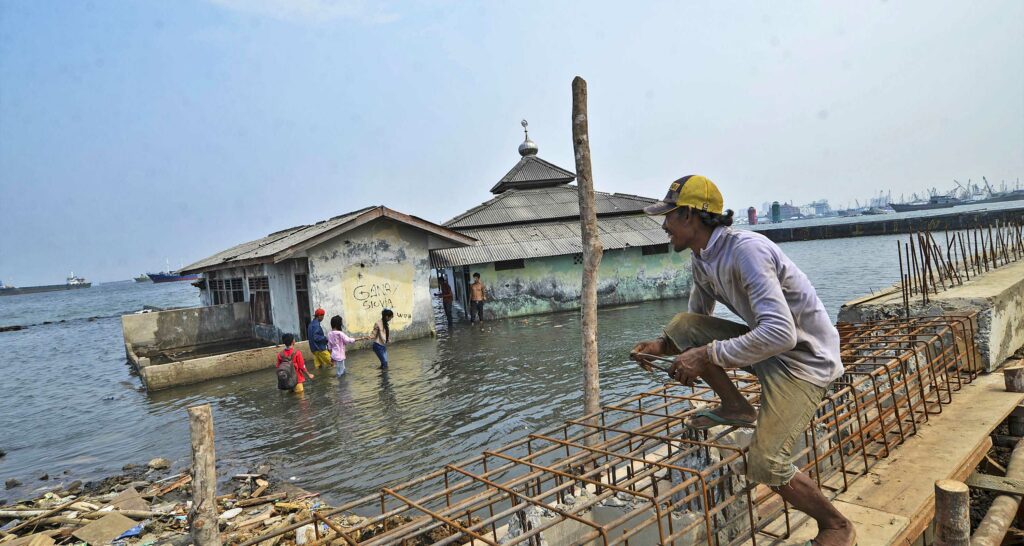
At the same time, Jakarta is experiencing increased tidal flooding. One factor is thought to be rising sea levels due to climate change. But far more critical is land subsidence of 10cm or more a year in Jakarta’s coastal areas. A business-as-usual trajectory predicts that 40% of Jakarta will be under water by 2050, stretching up to 5km inland from the current coastline.
Jakarta’s subsidence is caused by increased load on the land. The city’s development area contains many high-rise buildings, each demanding massive amounts of water. Surface water cannot meet the demand, so much of the water comes from deep wells. This continuous depletion of deep groundwater means the ground above it is sinking.
To compound this, the city is also on a flood plain in an area that recorded average monthly rainfall of 171.79mm over the last four years. Generally, flooding occurs when monthly rainfall tops 200mm. In January 2020 rainfall hit 618mm and in February rose to 1023.4mm, leading to extensive flooding over several days. Future flooding poses obvious risks for the city’s 10.65 million residents, many of whom live in densely packed housing developments along the banks of the river. But with 60% of Indonesia’s money supply located in Jakarta, any risk to the city threatens the entire Indonesian economy.
Efforts and obstacles
To address the problem, central government, Jakarta’s provincial government, and neighboring provinces have carried out various spatial planning efforts, including hydrological technical control measures. In 2008, a spatial policy was formulated for the Greater Jakarta, or Jabodetabekjur, area. In 2020 the policy was updated in line with dynamic regional development realities.
The plan stipulates that each building must not cause increased water discharge to the drainage or river flow systems, a principle known as zero delta q. In addition, the plan also emphasizes strategies to:
- green the upstream area of the watershed as a protected area
- rehabilitate forests and land
- green the catchment area
- organize the border area of the river and its tributaries, including controlling development on the river border
The plan also reaffirms the need to maintain green open space at a minimum of 30% of the urban area.
Other measures implemented by the central government and the province of Jakarta include:
- building three reservoirs in the central Ciliwung watershed (higher than the coastal area) to mitigate flood risk
- maintaining the west and east flood canals (built by the Dutch about 100 years 50 years ago, respectively), which control sedimentation to smooth the flow of the river into the sea
- several programs to improve the function of lakes and ponds in the Jakarta area and its polder system (tracts of low land reclaimed from bodies of water)
Despite these efforts, major obstacles to successfully saving Jakarta from flooding remain. These include:
- problems around land acquisition
- low levels of community participation
- poor cooperation between local and central government
- a lack of systemic and holistic understanding of natural systems, especially hydrological systems
Residents’ awareness of the flooding hazard still appears to be lacking, as flooding continues to occur where people live. Generally, people are staying in flood-prone areas as they are more concerned with the value of assets and socio-economic activities that have been carried out for many years. Despite various public service advertising campaigns, much more must be done to increase the population’s resilience to flooding.
A strategy for sustainable development
Given the scale of the problem, and these challenges, Indonesia’s Parliament has approved a bill to move the national capital from Jakarta to outside Java, to the province of East Kalimantan. This strategic decision to relocate Indonesia’s capital city will reduce the burden of flood management in Jakarta. Furthermore, it is hoped that relocating the capital can provide the impetus for putting Indonesia on a course to sustainable development.
Realistically, managing the risk of flooding is already an inseparable part of achieving Agenda 2030. As Robert Glasser, Special Representative of the Secretary-General for Disaster Risk Reduction, stated in 2015:
“Development that is not risk informed cannot be sustainable. Recurring disaster losses are a significant brake on poverty eradication. The implementation of the Sendai Framework for Disaster Risk Reduction is essential for the achievement of the Sustainable Development Goals [SDGs].”
Flooding is specifically referenced in SDG 11 (sustainable cities and communities) and SDG 13 (climate action). In many urban areas flooding impacts both workers’ homes and workplaces, disrupting or even eliminating jobs (SDG 8 on decent work and economic growth, and SDG 9 on industry, infrastructure, and innovation). The local economic effects can be even more pronounced if floods occur in an agricultural area in a village.
As a natural phenomenon related to the dynamics of life and development activities, flooding will directly impact too upon SDG 1 (no poverty) and SDG 2 (zero hunger). The indirect impact of flood events can also negatively impact other Goals such as SDG 5 (gender equality) SDG 15 (life on land).
The development agenda set out in Indonesia’s Medium-Term Development Plan or Jakarta’s Detailed Spatial Plan must be carried out by the local government working with all other stakeholders in the area. Of course, the work will require sufficient development budget, human resources, and implementation facilities. However, a forthcoming study on the coordination and capacity of SDG implementation in Indonesia (by the Asian Development Bank and United Cities and Local Governments shows that there is a weak point in the readiness and capacity of human resources among government, businesses, and social institutions. Similarly, it notes that the ability to manage floods is hampered by a lack of planners and implementers. Broadly speaking, Indonesia is still reactive to flooding, leading to significant losses and casualties.
Creating a new culture around flood risk
We already know what is fueling the acceleration of flood-prone areas in Indonesia: population growth and distribution, decision-making around socio-economic activities, and too much development in flood-risk areas. To achieve a society with high resilience that can also develop sustainably, we must embark on an intensive process of strengthening knowledge to create a new widespread culture of attitude and behavior around managing flood risk.


