Guiding climate action through Earth observation
With their unwavering gaze from above, satellites are an increasingly powerful tool to identify and monitor anthropogenic emissions, right down to pinpointing individual sites. Using this data to inform policy and direct climate action everywhere must be an urgent global priority
Climate — Global
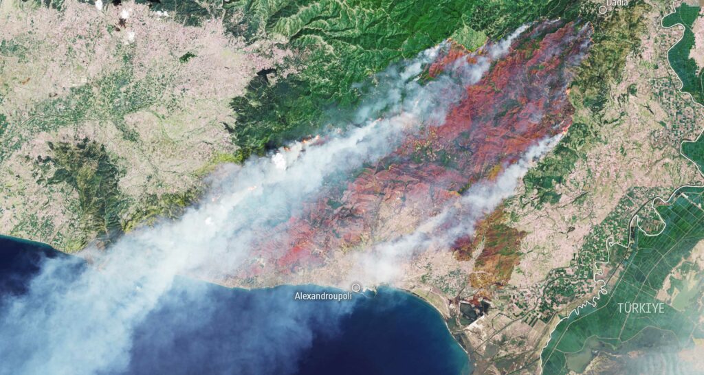
Satellites have revolutionized scientists’ grasp of the climate and its evolution over recent decades. These orbiting marvels have provided the observational records to validate and improve the Earth system models used to predict future change. Beyond supporting the science, satellites are becoming critical tools in the quest to tackle climate change and monitor progress toward a lower-emissions and more resilient world.
Reducing emissions of greenhouse gases (GHGs) such as carbon dioxide (CO2) and methane is clearly paramount to avoid the worst impacts of climate change. The Intergovernmental Panel on Climate Change (IPCC), the body responsible for assessing the state of the climate, warned earlier this year that immediate and dramatic emissions cuts are needed to limit global temperature rise to 2°C – and even 1.5°C as best effort – relative to the pre-industrial era, reiterating the urgent need for all nations to decarbonize.
Emerging scientific methods and technologies from the Earth observation (EO) sector are playing a growing role in guiding actions that can curb emissions in two important aspects. First, new methods allow comparison of GHG inventories against independent space observations to track national progress toward lower emissions. Second, the latest high-resolution satellite missions provide new capabilities that enable detection and quantification of emissions hotspots resulting from fossil-fuel combustion down to the region, city, or even plant scale. This can inform and direct effective action and policies aimed at curbing carbon emissions.
Taking stock of global climate action
Later this year, the international community convenes at the COP28 climate summit in Dubai to conclude the first global stocktake. This five-yearly assessment cycle reviews global action to curb emissions and inform where nations need to increase and accelerate initiatives to maintain progress toward the Paris Agreement’s warming goals.
For the process to be robust, accurate and consistent reporting is needed at the national scale. Currently, the national GHG emissions inventories, which are reported to the UN Framework Convention on Climate Change (UNFCCC) as part of the stocktake process, are compiled using emissions factors and national statistics. In essence, the inventories are scaled-up estimates of national carbon emissions and removals.
To increase the accuracy and confidence in these inventories, the IPCC encourages countries to verify reported emissions against independent measurements. If compared against EO data, for example, this offers greater confidence that emissions reporting reflects the real-world situation – as well as improving transparency.
New research (‘Comparing national greenhouse gas budgets reported in UNFCCC inventories against atmospheric inversions’) conducted via the ESA-funded Regional Carbon Assessment and Processes (RECCAP-2) project developed a framework to directly compare national inventories against state-of-the-art satellite observations.
The project researchers combine satellite-derived observations and in-situ measurements with inversion models that help to factor the “flux” or movement of GHG emissions between land and atmosphere. This top-down approach offers a full picture of the emissions that accumulate in the atmosphere at the country scale. This is then used to check national inventories to enhance GHG reporting.
Currently, only large, high-emitting countries can be assessed. But with denser satellite sampling anticipated in the coming years, more countries are set to benefit.
This work has highlighted inconsistencies between national emissions reporting and observations. For example, methane emissions, particularly for Gulf states that extract oil and gas, and forest carbon stocks in northern hemisphere countries were generally underreported when compared with observations. Such insight and checks will enable increased accuracy and confidence and consistency in GHG emission reporting and progress toward nationally determined carbon reduction commitments.
Figure 1. Carbon dioxide flux from managed land in Canada
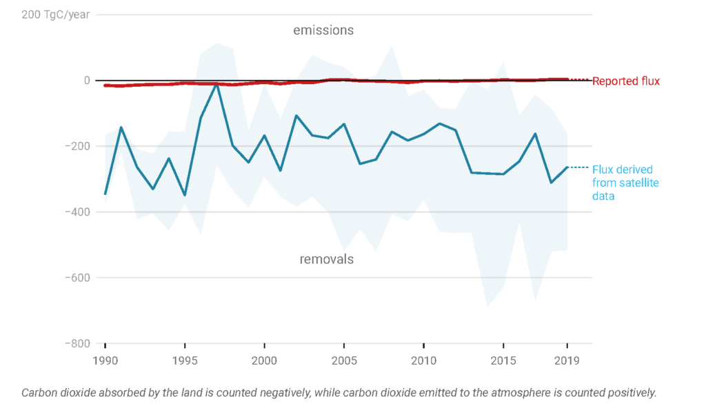
Chart: European Space Agency. Source: Deng et al. 2021.
As Philippe Ciais of the Laboratoire des Sciences du Climat et de l’Environnement (LSCE) and RECCAP-2 science leader notes: “If regularly applied, the methods will not only improve transparency in the accounting process but will also improve the effectiveness of mitigation policy and progress by individual countries to meet their pledges as part of the Paris Climate Agreement.”
Building on similar research methods, ESA is developing World Emission. This emissions-monitoring service leverages satellite data from the European Commission’s Copernicus program, from space agencies such as the Japan Aerospace Exploration Agency (JAXA) and NASA, and complementary ground-based measurements. This unique global coverage project will generate global maps for CO2, methane, and several atmospheric pollutants. It will provide essential information for policymakers, governments, national reporting agencies, and subsidiary bodies to enhance pollutant and GHG emissions inventories. It’s just one example of how EO can demonstrate its uniqueness and excellence to complement traditional information, contributing significantly to the overall drive for climate change mitigation.
Enhancing carbon markets
Carbon markets, both compliance and voluntary, offer another fundamental system to stimulate the shift toward net-zero emissions. The role of EO to improve quality and transparency, provide solutions globally, and increase trust in these growing markets was made clear at the recent ESA-organized EO for Carbon Markets Forum 2023. The forum convened representatives from the European Commission’s Directorate-General for Climate Action and Joint Research Centre, along with certification bodies, public agencies, finance and insurance entities, carbon project operators, the EO industry, non-governmental organizations, and academia.
Existing projects are already demonstrating the relevance of EO to support carbon credits certifications. For example, the ESA Forest Carbon Monitoring project develops EO-based, user-centric approaches to support forestry stakeholders to meet the requirements of both compliance and voluntary carbon markets. The project involves developing a prototype cloud processing platform that offers a selection of biomass and carbon monitoring approaches for both large and small areas.
Satellites to detect and monitor anthropogenic emissions
Anticipated for launch in 2026, ESA is developing the Copernicus Anthropogenic Carbon Dioxide Monitoring (CO2M) mission on behalf of the EU, as one of the six Copernicus Sentinel Expansion missions.
These new missions aim to bolster the scope of the EO component of Copernicus, with CO2M providing CO2 monitoring capability to support decarbonization efforts across Europe and beyond.
Forming a constellation of two satellites, each carrying a near-infrared and shortwave-infrared spectrometer, the CO2M mission will provide a global picture of atmospheric CO2 concentrations at high spatial resolution every four days. These data will feed into the new CO2 Monitoring and Verification Support capacity being developed by the European Centre for Medium-Range Weather Forecasts. Once operational, the mission will reduce uncertainties in estimates of emissions of CO2 from the combustion of fossil fuel at local, national, and regional scales.
CO2M will be the first mission to monitor anthropogenic carbon emissions and is anticipated to provide data to support the second global stocktake that concludes in 2028, as well as the dramatic decarbonization of Europe’s economies needed to deliver the Green Deal.
By providing a unique and independent source of information, CO2M will be key to assessing the effectiveness of policies aimed at curbing emissions at both national and global scale, enabling countries to track and show how they are progressing against their decarbonization commitments. The ability to detect and quantify major CO2 emission hotspots within national borders, at the city or plant scale, is anticipated to help coordinated efforts to tackle major emissions sources.
Indeed, satellite observations are already playing a pivotal role in the global effort to combat climate change. The Copernicus Sentinel-5P mission, launched in 2017, is delivering global maps of anthropogenic methane concentrations to guide climate action on a daily basis.
Figure 2: Sentinel-5P detected methane plumes
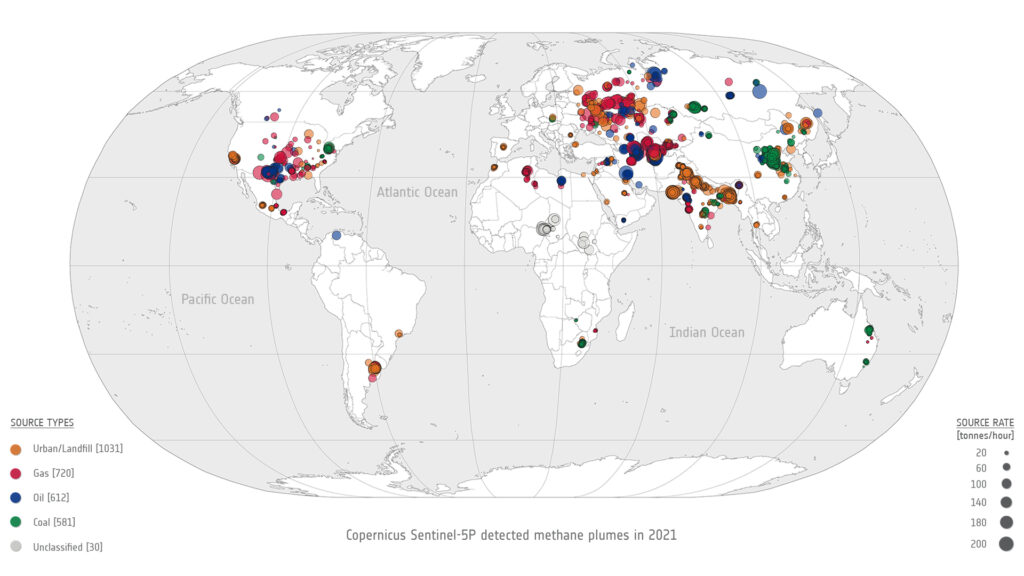
Source: European Space Agency
Researchers from SRON (the Netherlands Institute for Space Research) can now identify and quantify major industrial methane leaks from oil, gas, and landfill sites. In 2021 alone, researchers discovered nearly 3,000 methane plumes, equivalent to the annual total GHG emissions of the Netherlands, according to SRON research (‘Automated detection and monitoring of methane super-emitters using satellite data’).
As industrial methane leaks are relatively simple to fix, space-borne detection offers a golden opportunity to cut emissions, with the UN International Methane Emissions Observatory using this data to find solutions with companies and authorities.
Swift, deep, and sustained climate action is needed to avoid the worst consequences of climate change. Advances across the EO sector are playing a growing role to help transition to a lower-emissions, net-zero world.

